Cahaba Basin
Geologic area of central Alabama, USThe Cahaba Basin is a geologic area of central Alabama developed for coal and coalbed methane (CBM) production. Centered in eastern Bibb and southwestern Shelby Counties, the basin is significantly smaller in area and production than the larger Black Warrior Basin in Tuscaloosa and western Jefferson Counties to the northwest. The coalbed methane is produced from the Gurnee Field of the Pottsville Coal Interval. Coalbed gas production has been continuous since at least 1990 and annual gas production has increased from 344,875 Mcf in 1990 to 3,154, 554 Mcf through October 2007.
Read article

Top Questions
AI generatedMore questions
Nearby Places
Bibb County, Alabama
County in Alabama, United States
Centreville, Alabama
City in and county seat of Bibb County, Alabama

Cahaba River National Wildlife Refuge
National Wildlife Refuge in Alabama, US
Centreville Historic District (Centreville, Alabama)
Historic district in Alabama, United States
Bibb County High School
Public high school in Centreville, Alabama, United States
Bibb County School District (Alabama)
School district in Bibb County, Alabama, U.S.
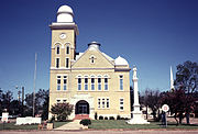
Bibb County Courthouse (Alabama)
United States historic place
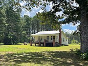
Gary Springs, Alabama
Unincorporated community in Alabama, United States